House For Sale Wolverhampton Road, Kingswinford, DY6
£500,000
1 of 3
- Description
- Street View
- Maps
Last Updated: 24th April 2024
Description
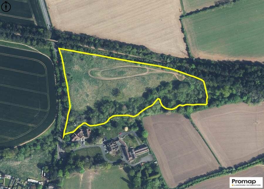
The site comprises a parcel of land equating to 8.16 acres (3.30 hectares) of greenfield land lying to the north of the main built up area of Kingswinford.
The site is bounded by Wolverhampton Road to the west, the South Staffordshire Railway Walk to the north woodland and agricultural land to the east, and Holbeche House, Riverside Care Centre, and agricultural land to the south.
The site benefits from direct access off the Wolverhampton Road, known as the A449.
A topographic survey is available on request.\r
\r
The site is located approximately 1.5 miles north west of Kingswinford, situated in the suburban village of Wall Heath. Wall Heath lies 5 miles (8km) west of Dudley Town Centre, 9 miles (15 km) north of Kidderminster, and 14 miles (22km) west of Birmingham City Centre. This site is located on the border of Dudley Borough and South Staffordshire Councils.
The site is sustainably located with easy access to local facilities, public transport links, employment areas, primary schools, a supermarket and the public rights of way network.
The closest school is Maidensbridge Primary School that lies c.800m to the west of the site; there is a Morrisons supermarket that lies approx. 1400m to the south of the site and the Ham Lane Industrial Estate lies some 950m to the east of the site.
Agent Details
Savills New Homes
55, Colmore Row, Birmingham, B3 2AA
Show Contact Number
0121 200 4500
Investment Analysis
Annual Rent:
Annual Mortgage Interest:
Annual Costs:
Calculators
Mortgage Finder
Show me the cheapest mortgage for this property matched to my personal circumstances and risk appetite.
No minimum income required
Similar Properties
A few properties that are similar to this property. See more properties like this.

£95,000
Kingswinford, DY6
Flat
6.7

£100,000
Kingswinford, DY6
Flat
6.4

£139,950
Kingswinford, DY6
Ground Floor Flat
4.5
Legal - YOUR PROPERTY MAY BE REPOSSESSED IF YOU DO NOT KEEP UP REPAYMENTS ON A MORTGAGE OR ANY DEBT SECURED ON IT.
Property Forecaster are working in partnership with Midland Mortgage Bureau Limited. Midland Mortgage Bureau Limited is an appointed representative of The Right Mortgage Ltd, St Johns Court,70 St Johns Close, Knowle, B93 0NH, which is authorised and regulated by the Financial Conduct Authority. Midland Mortgage Bureau Limited financial Services Register number is 756490. The Right Mortgage Ltd Financial Services Register number is 649443.
Property Forecaster are working in partnership with Midland Mortgage Bureau Limited. Midland Mortgage Bureau Limited is an appointed representative of The Right Mortgage Ltd, St Johns Court,70 St Johns Close, Knowle, B93 0NH, which is authorised and regulated by the Financial Conduct Authority. Midland Mortgage Bureau Limited financial Services Register number is 756490. The Right Mortgage Ltd Financial Services Register number is 649443.