This property has been taken off the market.
House For Sale Main Street, Rotherham, S66
£300,000
1 of 1
- Description
- Street View
- Maps
Last Updated: 23rd May 2024
Description
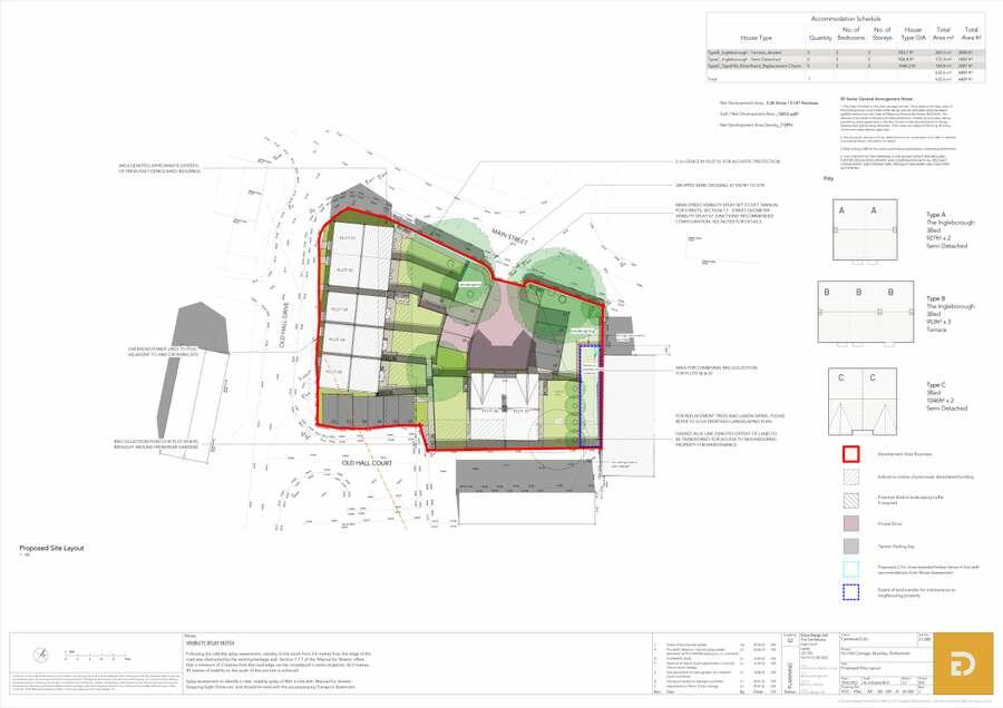
The subject site area is approximately 0.36 acres (0.146 hectares), as outlined in red on the indictive site plan below. The site is currently cleared land, formerly comprising a row of historic cottages. The site is surrounded by residential housing to the western, southern and eastern boundaries, with Main Street to the north. There is a historic Methodist chapel bordering to the eastern boundary. The topography of the site is generally flat.\r
\r
The site is located in the Bramley and Wickersley suburbs of Rotherham, approximately 5 miles east of the town centre. There are a range of services and facilities within the nearby vicinity, including a primary school, Aldi supermarket, McDonalds and Bannatyne Health Club.
\r
The site is located in the Bramley and Wickersley suburbs of Rotherham, approximately 5 miles east of the town centre. There are a range of services and facilities within the nearby vicinity, including a primary school, Aldi supermarket, McDonalds and Bannatyne Health Club.
Agent Details

Savills
3 Wellington Place, Leeds, LS1 4AP
Investment Analysis
Annual Rent:
Annual Mortgage Interest:
Annual Costs:
Calculators
Mortgage Finder
Show me the cheapest mortgage for this property matched to my personal circumstances and risk appetite.
No minimum income required
Similar Properties
A few properties that are similar to this property. See more properties like this.

£125,000
Rotherham, S66
Cottage
8.4

£165,000
Rotherham, S66
Semi Detached
5.3

£125,000
Rotherham, S66
Terraced
4.7
Legal - YOUR PROPERTY MAY BE REPOSSESSED IF YOU DO NOT KEEP UP REPAYMENTS ON A MORTGAGE OR ANY DEBT SECURED ON IT.
Property Forecaster are working in partnership with Midland Mortgage Bureau Limited. Midland Mortgage Bureau Limited is an appointed representative of The Right Mortgage Ltd, St Johns Court,70 St Johns Close, Knowle, B93 0NH, which is authorised and regulated by the Financial Conduct Authority. Midland Mortgage Bureau Limited financial Services Register number is 756490. The Right Mortgage Ltd Financial Services Register number is 649443.
Property Forecaster are working in partnership with Midland Mortgage Bureau Limited. Midland Mortgage Bureau Limited is an appointed representative of The Right Mortgage Ltd, St Johns Court,70 St Johns Close, Knowle, B93 0NH, which is authorised and regulated by the Financial Conduct Authority. Midland Mortgage Bureau Limited financial Services Register number is 756490. The Right Mortgage Ltd Financial Services Register number is 649443.